Smart watches and Bluetooth BLE beacons realize the working principle of indoor positioning
The main positioning method of smart GPS watch is GPS, and this positioning method can usually only be located in the case of Open Sky. Although most smartwatches can make up for the lack of GPS indoor positioning through base stations and WIFI positioning, it is difficult to achieve accurate indoor positioning, such as positioning to specific floors, specific rooms, etc. Indoor accurate positioning for smart pension, smart construction site, mine management, airport staff management, large shopping mall security management, prison management and other solutions for indoor positioning is very necessary.
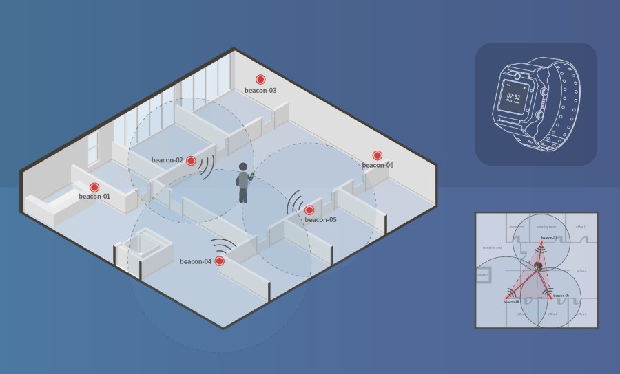
When we manage a multi-storey large venue, we will cover the Bluetooth BLE beacon on each floor on average, about every 50 square meters of a Bluetooth BLE beacon density, because the Bluetooth beacon low power consumption, long standby time, usually installed a battery can be standby for 2-3 years, so the installation of Bluetooth BLE beacon maintenance costs are low. After the Bluetooth beacon is installed, if the person wearing the smart GPS watch enters these venues, the Bluetooth module in the watch will search for the surrounding Bluetooth BLE beacons, usually two or three at the same time, and the Mac address of these beacons will be transmitted to the server. The server software can achieve accurate indoor positioning through the installation location of these Bluetooth BLE beacons and multi-point cross-positioning, usually with an accuracy of 1-5 meters or even higher, accurate to the floor and room.
Steps to realize indoor positioning
You can obtain the accurate plan of each floor of the venue, and upload the plan into your software to realize the indoor positioning map engine, that is, you can convert the plan into a map with coordinate system. This function can be achieved through many open source tools, such as the Leaflet component we use.
The first step after making the interior map engine is to upload the floor plan and give the floor plan a name, for example, this is the first floor of X building.
After uploading the plan, you can mark the beacon on the map against the actual installation point of the beacon, and add the Mac address and address name of the beacon, such as conference room A, activity room B, etc. With a standard beacon, you will save the coordinates of the map and the name of the plan, which is used to calculate the coordinates of the indoor positioning.
The server software receives the beacons uploaded by the smartwatch, and finds the coordinates of their installation through the MAC address of the Bluetooth beacons, and can accurately calculate the position through multiple coordinates.
Refer to the steps in the case Traxbean system:
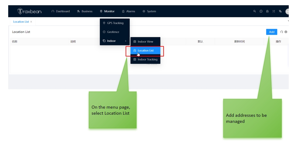
1. In the Traxben GPS Tracking system, select Indoor Location, select Location List on the menu page, and add the address to the menu.
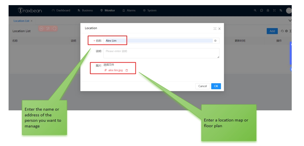
2. Enter the Location page, enter the name and home address of the monitor, and upload the flat plan.

3, In the Location list, select the monitor Menu “menu” and select “View “to enter the indoor map setting page.
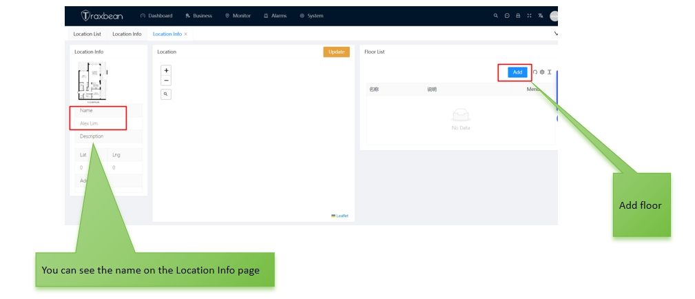
4. In the Location Info page, add the floor plan map.
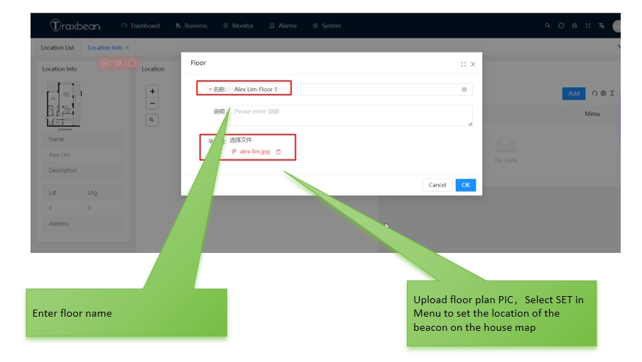
5, Enter the floor name, and upload the floor plan.

6. On the Beacon beacon page, click any location of the flat map to enter the beacon MAC address. (In the real world, the location of the beacon should be the same as the location of the map beacon.)
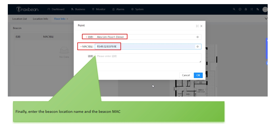
7, Enter the floor room name and beacon MAC address.
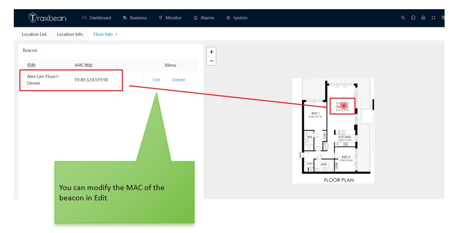
8. Beacon MAC locations can be added to other rooms in the flat plan, and beacon MAC addresses can also be modified.
Thus, the indoor positioning setting of Traxbean GPS Tracking Bluetooth beacon is completed, and accurate indoor positioning monitoring can be realized in the background system.